Seoul unveils blueprint for elevated bike paths

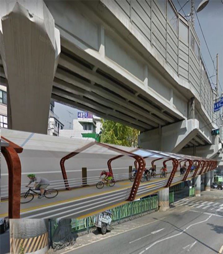
The computer generated image of “UNDER the C,” a cycling path attached to an elevated expressway between Seokgye Station and Jeongeung Station in northeastern Seoul, which won first place in the Eco-Bike Line design competition hosted by the Seoul Metropolitan Government. Courtesy of Seoul Metropolitan Government
Seoul City announces winning designs in Eco-Bike Line competition
By Lee Suh-yoon
Seoul has announced the winners of an architectural design contest for elevated bike paths that can provide cyclists a more continuous and safer ride around Seoul.
The first prize went to a submission titled “UNDER the C,” which drew up plans for a bike path beneath an elevated expressway in northeastern Seoul. If built, this elevated bike lane will connect cyclists in the Jeongneung Station area to the Jungnang stream, whose bike paths eventually connect to those along the Han River in the south.
Three designs were listed for a second place. One put a bike path under the elevated tracks of Seoul Metro Line 4 in northeastern Seoul. Two placed them under bridges crossing over the Han River.
A computer generated image of “Lighting up the heart of dark Nowon,” a bike lane that will run along the elevated sections of Seoul Metro Line 4 in northeastern Seoul. Courtesy of Seoul Metropolitan Government
The winning designs ― including 10 honorable mentions and 30 finalists ― will be incorporated into the final blueprint for Seoul's “Eco-Bike Line” project, which plans to build a network of elevated cycling paths underneath the city's overpasses and bridges. The winners were evaluated based on creativity, connectivity and feasibility.
The project is inspired by similar feats in other international cities. Xiamen, a city in southeastern China, recently opened a 7.6-kilometer-long bike-exclusive skyway below an elevated bus route. Copenhagen's Cycle Snake bridge across the city harbor served as a benchmark.
Though still in the preliminary planning stages, Seoul's plans are comparable to London's Sky Cycle project ― which would have built a 200-kilometer network of cycling paths above London's rail lines if not for the lack of funding. The stalling has led to criticism that the project may not yield proportional benefits to the required costs.
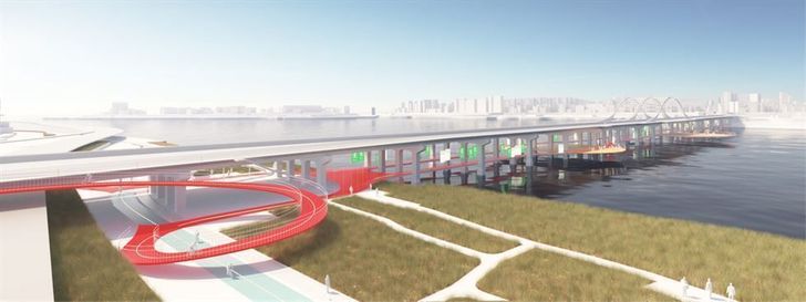
A winding elevated bike path connected to Yanghwa Bridge on the Han River, titled “Seoul Rider: creation of a new cityscape,” tied for second place along with two other designs. Courtesy of Seoul Metropolitan Government
Similarly, Seoul wants to build a web of elevated cycling paths that can connect the detached bike lanes at ground level and make bike travel easier and safer throughout the city.
“To stimulate eco-friendly transport methods like cycling, we must overcome the limits of ground-level infrastructure and review more future-oriented bikeway plans that can use the city's flyovers and bridges,” Ko Hong-seok, a Seoul Metropolitan Government transport official, said in a press statement. “Taking into consideration these winning designs and exemplar cases from other countries, we hope to create a safer cycling infrastructure in the city.”
There are currently around 900 kilometers of ground-level bike lanes in Seoul. However, only the paths along the Han River Park ― around 260 kilometers ― provide a continuous and safe path separated from vehicles and pedestrians.